

Go To Page 1 Early Maps
|
Medieval Maps
Maps drawn in the middle ages are quite different from the maps as we know today. These were more like diagrams of landscape, regions or of continents drawn for specific purposes.
Although cartographically poor, some of these maps are very detailed and eloborate and cover all the geographic knowledge of the period in Europe.
While Islamic cartography was accessible in the middle ages, evidence of the continuation of this tradition is seen only in a limited number of maps produced during this period. Even some of the most important medieval maps have no obvious antecedents and their makers are largely unknown.
Until the 15th Century the world map was a simplistic diagram now referred to as the T-O form. This circular form consisted of an ocean around its circumference with three continents Europe, Asia and Africa separated by "T" shaped waterway.
Although the maps displayed below are all world maps, Anatolia is clearly visible.
|
|
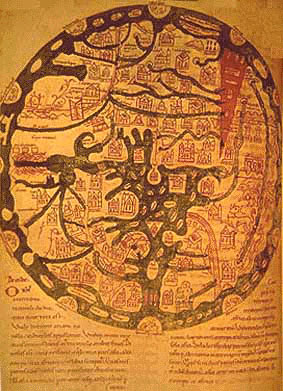 |
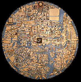
ISIDORE WORLD MAP, 7th Century
The eleventh century version of the seventh century world map of Isidore, Bishop of Seville is an elaborated version of the T-O map covering Europe, Asia and Africa. The east is towards the top of the map.
The map schematically show some rivers, mountains, islands and cities.The sea in the centre is the Mediterranean with its islands. The red wedge shape is the Red Sea.The Black Sea and Anatolia are barely recognizable.
For more information please click on the map.
|
|
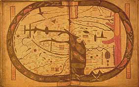 |
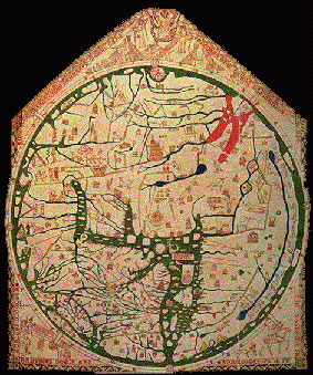
THE BEATUS WORLD MAP, Beatus of Liebana, St. Sever ca. 776 A.D.
This work was executed ca. 1050 A.D. at the St. Sever Aquitanian monastery by the order of Geogory de Muntaner, Abbot from1028 to 1072 A.D. The St. Sever derivative is considered by most scholars as the most valuable, the most carefully executed and the richest in content of all the ten transcripts of Beatus.
The east is to the top of the map. The thin waterway to the North (left of the map) is the Eagean, the Sea of Marmara and the Black Sea. Anatolia is not shown as a peninsula and it is hardly racognisable.
For more information please click on the map.
|
|
.jpg) |
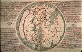
WORLD MAP OF AL-IDRISI, Abu Abdullah Mohammed Ibn al-Sharif al-Idrisi, 1154-1192
During the Middle Ages the Greek tradition of research was stifled in Western Europe by a theological dictatorship. Meanwhile the Moslems were discovering the works of Greek and Persian geographers. Most Arab cartographers also used Ptolemy's instructions in the construction of their own maps. With this basis the Moslems combined the accumulated knowledge gained through exploration and travel. Idrisi fused elements from East and West with Arab knowledge to produce a world-picture.
In this map of the world covering Europe, Asia and Africa the south is oriented to the top of the map. Here Anatolia is clearly shown.
For more information please click on the map.
|
|
 |
EBSTORF MAPPAMUNDI, Gervase of Tilbury, c. 1234
This map of the world, like its English counterpart, the Hereford mappamundi produced later in the same century, sums up a medieval European-Christian cartographic tradition.
Its name stems from the fact that it was preserved in a Benedictine monastery in Ebstorf, until its discovery in 1830.
The Ebstorf map does not present any breakthroughs of either cartographic or geographic nature. The cartographer however accomplishes to describe the sum total of accumulated knowledge about man's habitat, the world, resulting in a comprehensive pictorial encyclopedia of the world as it was seen by a great many medieval Europeans.
For more information please click on the map.
|
|
 |
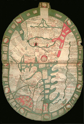
THE HEREFORD MAPPAMUNDI, Richard de Bello, c. 1290
This is the largest map of its kind to have survived in good condition from such an early period of cartography. It has been preserved in the Hereford Cathedral (England) for almost 700 years. Besides its antiquity, it is notable for the quality of its workmanship and for the variety of the drawings which adorn it.
In design, the Hereford map can be labelled a modified and extremely elaborate T-O plan. As is traditional with the T-O design, there is the tripartite division of the known world into three continents: Europe, Asia, and Africa. As previously mentioned, East is at the top of the map, and the whole is surrounded by the uncrossable great ocean.
Asia Minor is depicted, between the Aegean Sea and the Black Sea, along with Troy, Laodicea, Antioch, and Noah's Ark.
For more information please click on the map.
|
|
 |
THE VESCONTE MAPPAMUNDI, Pietro Vesconte, c. 1306 - 1321
Pietro Vesconte is considered as the first professional cartographer to sign and date his works regularly. He was one of the few people in Europe before 1400 to see the potential of cartography and to apply its techniques with imagination. As can be seen in the world map he drew around 1320 he introduced a heretofore unseen accuracy in the outline of the lands surrounding the Mediterranean and Black Sea, probably because they were taken from the portolan [nautical] charts.
Vesconte's world maps were circular in format and oriented with East to the top,The Mediterranean, the Black Sea and Asia Minor, are no longer an unrecognizable pattern of shapes that can be identified only by names attached to them; instead they are drawn just as in a normal portolan chart.
For more information please click on the map.
|
|
 |
HIDGEN WORLD MAP, Ranulf Higden, ca. 1350
Elaborate diagram-maps, in the tradition of the early medieval world maps, were still being produced in the 14th and 15th centuries. One of them, is a mid-14th century map by Ranulf Higden, a Benedictine monk at Chester (ca. 1299-1363).
The water areas are shown in green (except for the Red Sea shown in red). Islands are shown as blocks of text.
The map is oriented with East at the top. The Mediterranean and The Black Sea are quite distorted around Asia Minor. Rivers Euprates and Tigris are exagerated and shown as originating from a body of water.
For more information please click on the map.
|
|
|
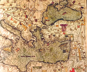 |
CATALAN ATLAS, Abraham Cresques, ca. 1375
This is a detail from the Catalan Atlas which was commissioned by the French King Charles V. The work was carried out by a family of Catalonian Jews who worked in Majorca.The 'atlas' that resulted contained the latest information of its time and is considered "the most complete picture of geographical knowledge as it stood in the later Middle Ages.The original Atlas is in the Bibliotheque Nationale, Paris, and it is in the form of seven loose wooden panels.
The map is cartographically well developed for its time and it is is in the form of a portalon map (nautical chart). It is quite detailed and the figures make it very attractive.
For more information please click on the map.
|
|
|
 Recommended
 Recommended