 |
|
16th - 17th Century Maps The awakening of interest in geography in Europe started with the need to find new trade routes to the Far East. This was very much inspired by the rediscovery of Ptolemy's Geographia. Manuscript copies of this work were brought to Italy from Constantinople and widely studied. The invention of printing in 1450 made the circulation of knowledge wide spread. The development of improved methods of surveying and invention of more precise instruments enabled large areas to be surveyed. Starting in Italy and Central Europe, map making and Atlas publication moved to Netherlads where Gerard Mercator produced his first map on the new projection in 1569 and Ortelius published the first modern atlas Theatrum Orbis Terrarum in 1570. Due to great interest in these publications, maps of superb quality were produced making this period the golden age of cartography. This period corresponds to the height of Ottoman Empire. Below are maps of the empire and Anatolia from the atlases of the prominent map makers and publishers of the period. It is interesting that Ottoman Empire is referred to as Turkish Empire in almost all the maps of this period.
|
|
|
|
||
.jpg) |
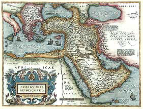
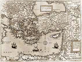
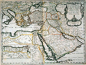
Turcici Imperii Descriptio, Antwerp c. 1570
ORTELIUS, Abraham (1527 - 1598) Detailed map from Theatrum Orbis Terrarum covering the Ottoman Empire at its height, including territories in Balkans, Anatolia, Levant, Arabia and North Africa. Size 375 x 494mm. Theatrum Orbis Terrarum is accepted as the first "Atlas" in the modern sense. This book of maps became the most successful cartographic production of its time and was published for many years. Engraved mainly by Franz Hogenberg and printed by Christoffel Plantijn, the first edition consists of seventy maps on fifty-three sheets assembled from the best available sources. Click on map to enlarge. |
|
|
|
||
 |
Turcici Imperii Descriptio, Antwerp c. 1584
ORTELIUS, Abraham (1527 - 1598) A variation of Ortelius map from Theatrum Orbis Terrarum with a different cartouche. Size 375 x 494mm. |
|
|
|
||
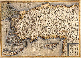 |
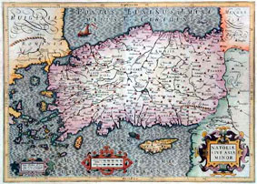
Natoliae Quae Olim Asia Minor Nova Descriptio, Antwerp c. 1584
ORTELIUS, Abraham (1527-1598) Map of Anatolia, Crete and Cyprus from Ortelius' Atlas Theatrum Orbis Terrarum. 322 x 232 mm. This map was printed in the Atlas with east oriented to top for better presentation. Here it is rotated horizontal for the same reason. Click on map to enlarge. |
|
|
|
||
 |
Turcia Turci Cive Imperii, Antwerp c. 1578
JODE, Gerard De (1509 -1591) Detailed and finely engraved map of Gerard De Jode from his Speculum Orbis Terrarum of East Mediterranean covering the Ottoman Empire territories in Europe, Anatolia and Levant. This is a black and white example. Size 380 x 510mm. The map has two title cartouches and three ships which make this map quite attractive. The upper cartouche indicate the geographical information Natoliam modern, dicunt eam partem quam Asiam Minorem apellavere veteres..... the lower cartouche indicate that it is a map of Turkish Empire. Another interesting feature is the Noah's Ark on Mount Ararat. Jode maps are quite rare compared to his contemporary Ortelius. This is mainly because only 2 editions of his atlas was printed compared to 42 editions of Ortelius atlas. Click on map to enlarge. |
|
|
|
||
.jpg) |
Natoliae Quae Olim Asia Minor Nove Descriptio, Rome c. 1592
BOTERO, Giovanni (1540 -1617) This is a small 20x15 cm but quite an unusual Italian map because it has been printed with South oriented to the top and the East to the left as if the map has been rotated 180° clockwise. It shows most of the important towns and rivers in the Anatolian peninsula and includes Thrace, Cyprus and Crete. Click on map to enlarge. |
|
|
|
||
.jpg) |
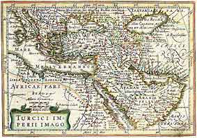
Turcici Imperii Imago, Amsterdam c. 1606
HONDIUS, Jodocus (1563 - 1612) Detailed map covering the Ottoman territories in Balkans, Anatolia, Levant, Arabia and North Africa published by Henricus Hondius in Atlas sive Cosmographicae Meditationes de Fabrica Mundi et Fabricati figura. Size: 365 x 485mm. The map has a decorative cartouche with the portrait of Ottoman Sultan Mahomet Turcorum Imperat 2. Jodocus Hondius is an important engraver from Ghent. He is known for the Mercator/Hondius Atlas he published with Mercator's plates to which he added his own. Click on map to enlarge. |
|
|
|
||
 |
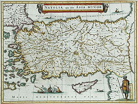
Natolie Sive Asia Minor, c. 1613
MERCATOR, Gerard A decorative map of Anatolia, Cyprus and Eagean islands with 3 attractive strapwork cartouches engraved by Jodocus HONDIIUS. Size 340 x 480mm. |
|
|
|
||
.jpg) |
The Turkish Empire, London c. 1627
SPEED, John (1552-1629) One of the most decorative maps of Turkish Empire from Speed's A Prospect of the Most Famous Parts of the World. The map covers Ottoman territories in the Balkans, Anatolia, Levant, Arabia and North Africa. Size 390 x 510 cm. Borders on each side show full length portraits of Greek, Egyptian, Assyrian and Persian men and women. Surprisingly, in this map of "Turkish Empire", there is not a Turk among the portraits of ethnic groups . The Arms of Turkey depicting a crowned crescent moon face figure is most certainly imaginary for I have never seen this in Ottoman sources. Town plans at the top are of Famagusta, Damascus, Alexandria, Jerusalem, Constantinople, Cairo and Ormuz. Click on map to enlarge. |
|
|
|
||
 |
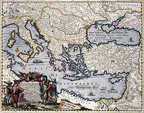
Turcici Imperii Imago, Amsterdam c. 1632
MERCATOR, G. / HONDIUS, J. A very finely detailed informative map Ottoman territories in the Balkans, Anatolia, Levant, Arabia and North Africa. This example has outline colouring. Size 132 x 191 cm.
|
|
|
|
||
.jpg) |
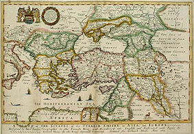
Turcicum Imperium, Amsterdam c. 1640
BLAEU, W. Janszoon (1571 - 1638) Detailed map covering the Ottoman Empire at its height including territories in Balkans, Anatolia, Levant, Arabia and North Africa. Willem Janszoon started the map publishing business of the Blaeu family in Amsterdam in 1599. With the Mercator plates he acquired, he published Atlantis Appendix in 1630 and Theatrum Orbis Terrarum in 1635. After his death, his son Joan Blaeu (1596 - 1638) published the Atlas Major which they have been working on. This Atlas is considered the most magnificent work of its kind. Click on map to enlarge. |
|
|
|
||
 |
NATOLIA quae olim ASIA MINOR, Amsterdam c. 1635
BLAEU, W. Janszoon (1571 - 1638) One of the most decorative maps of Anatolia. Size 380 x 510 mm. The title cartouche is decorated with turbaned heads at each end. Two Ottoman vessels are shown in a naval engagement with a foreign vessel. A man in local costume is shown next to the scale ruler.The map extends from theAegean to Euphrates river in the east and includes Cyprus and part of Crete. Click on map to enlarge. |
|
|
|
||
.jpg) |
Dioecesis Asiana Pontica Thracia, c. 1650
TAVERNIER, Melchoir A very decorative map of Anatolia and Thrace with bold outline colouring. Size 32x43cm. It has a very pretty title cartouche depicting a camel and people of the region. Click on map to enlarge. |
|
|
|
||
.jpg) |
Turcicum Imperium, Amsterdam c. 1665
DE WIT, Frededick (1630 - 1706) Detailed map covering the Ottoman territories in Balkans, Anatolia, Levant, Arabia and North Africa. Size 430 x 530 cm. The cartouche shows an Ottoman administrator or possibly the Sultan in a victorious pose with his aides on both sides. Below them are war prisoners. De Wit was an important engraver and publisher following the decline of Blaeu business. He acquired and published a number of their plates. His works were very popular and were reprinted for many years. Click on map to enlarge. |
|
|
|
||
 |
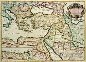
Estats de l'Empire du Grand Seigneur des Turqs ou Sultan des Ottomans en Asie, en Afrique, et en Europe, Paris c. 1654
SANSON, Nicholas Detailed map covering the Ottoman territories in Balkans, Anatolia, Levant, Arabia and North Africa by the leading French cartographer of the day. From Cartes generales de toutes les parties du monde. The states of the Ottoman Empire in Asia, Europe, and Africa are outlined in color. Includes an inset map of the kingdoms of Algeria, Tunisia, and part of Tripoli (Libya). The title cartouche features a turbaned sultan and two female figures. Size 390 x 525 cm. Click on map to enlarge. |
|
|
|
||
.jpg) |
Anatolie, Paris c. 1652
SANSON, Nicholas (1600 - 1667) Sanson's map of Anatolia and Cyprus. Size 185 x 235 mm. Click on map to enlarge. |
|
|
|
||
 |
Nova Totius Graeciae, Italiae, Natolae, Hungarie Nec Non Danubii Fluminis... Nurnberg c. 1660
SANDRART, Jacob (1630-1708) A regional map of Eastern Mediterranean countries covering the Ottoman territories in Europe, Anatolia, Middle East and North Africa. The map has a large and eloborate cartouche depicting Turkish and European soldiers of the time. Size 400 x 510 mm. Click on map to enlarge. |
|
|
|
||
 |
A Mapp of the Estates of the Turkish Empire in Asia and Europe, London c. 1670
BLOME, Richard A detailed and decorative map of the Ottoman territories in Europe, Anatolia, Middle East (Levant) and North Africa from A Geographical Description of the Four Parts of the World. In the main title at the bottom margin it is explained that this map was ''designed by Sanson, Geographer to the French King, and rendered into English and illustrated with figures by Richard Blome by the King's special command''. A copy of Sanson's map of 1650. Inside the wreath figure, it is indicated that the map was dedicated to the officials of the Company of Merchant Trading into the Levant Seas. Next to it there is a coat of arms which possibly is the insignia of that company. The map is further decorated with figures of ships, fish and a camel. Outlines are coloured. Size 250 x 400 mm. Click on map to enlarge. |
|
|
|
||
.gif) |
NATOLIA, quae olim Asia Minor, London c. 1673
OGILBY, John (1600-1676) A very beautiful and detailed map of Anatolia and Thrace with an exceptionally well engraved decorative title cartouche depicting what looks like local traders of the area. The map is also embellished with 4 ships and a decorative scale measure. The map cartographically looks like the Dutch maps of the period. Size 29x36 cm. Click on map to enlarge. |
|
|
|
||
 |
L'empire des Turcs en Europe, en Asie et en Afrique, Paris c. 1677
DUVAL, Pierres (1619 - 1682) A detailed French map covering all the Ottoman territories of the time in Europe, Middle East, North Africa including the westernmost provices in the inset map. Size 370 x 530 mm. From Cartes de Geographie. The map has a very decorative title cartouche with a turbaned head and a crescent on green background symbolising the Ottoman Empire and an inset of Algeria. Click on map to enlarge. |
|
|
|
||

 Recommended Recommendedreading |
 Recommended Recommendedreading |
||
|
|||