 |
|
18th - 19th Century Maps With the beginning of the 18th century we see a shift from the artistic map making tradition of the Dutch to production of more accurate and up-to-date maps led by French map makers such as Nicolas Sanson and continued by the British map makers in the next century. By 1800 map making moved into a new phase. Demand for more precise maps and the availability of accurate instruments and techniques developed cartography into a science. With regards to maps of Turkish Empire and Anatolia during this period, we begin to see the current local names of regions and cities as compared to the classical names shown in the earlier maps. With the decline of the Ottoman Empire we see major changes in the borders and emergence of new nation states in the Balkans and the Middle East.
|
|
|
|
||
.jpg) |
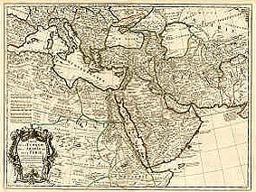
Accuratissima et Maxima Totius TURCICI IMPERII Tabula... Amsterdam, c. 1700
DANCKERT, Theodore The Turkish Empire, covering territories in Balkans, Anatolia, Levant, North Africa and Arabia. The map is based on earlier Dutch maps. It was originally issued by Justus DANCKERT in late 1600's. The map has an attractive cartouche depicting Ottoman men and a woman in the clothing of the period. Size 490x 585mm. . |
|
|
|
||
 |
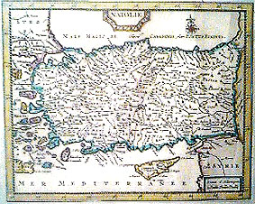
Carte de la TURQIE, de l'Arabie et de la Perse... Paris, c. 1702
L'ISLE, Guillaume de Extremely detailed regional map covering Ottoman territories in Balkans, Anatolia, Levant, North Africa and Arabia from the forerunners of scientific cartographers. The map is in outline colour and it includes many place names and geographical notes. There is a large decorative cartoushe. Size 480 x 630 mm. |
|
|
|
||
.jpg) |
Carte de L'EMPIRE OTTOMAN ... Amsterdam, c. 1720
CHATELAIN, Henri Abraham A large map of Turkish Empire, covering territories in Balkans, Anatolia, Levant, North Africa and Arabia. One of the few maps that cover the whole of the Mediterranean and include the western most provinces of the Empire in North Africa. The map has text on both sides which are cropped here due to space limitations. |
|
|
|
||
.jpg) |
La Perse, La Georgie, LA NATOLIE, Les Arabes, L'egipte et le Cours du Nile. Paris, c.1720
FER, Nicoles de A regional map showing the Asian territories of Ottoman Empire with emphasis on the course of river Nile. The map has an elaborate cartouche showing the ethnic population of the area. |
|
|
|
||
 |
Natolie, Leiden c. 1719
AA, Pieter Van Der Map of Anatolia and Cyprus. |
|
|
|
||
.jpg) |
Imperium Turcicum in Europa, Asia et Africa, Nurenberg, c.1720
HOMAN, Johann Baptist The Turkish Empire, covering the Balkans, Anatolia, Levant, North Africa and Arabia. The highly detailed black and white title cartouche depicts the subjects submitting to the Ottoman Sultan. This is a detailed map where names of regions and major cities are provided. Regions are distinguished by bright wash colors. Size 500 x 600 mm.
|
|
|
|
||
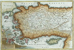 |
Asia Minor, c. 1730
CELLARIUS, Christophorus Map of Anatolia including Aegean islands and Cyprus with an attractive cartouche. 210 x 310 mm.
|
|
|
|
||
.jpg) |
MAGNI TURCARUM DOMINATORIS IMPERIUM, Augsburg, c.1736
SEUTTER, Mattheus The Turkish Empire, covering the Balkans, Anatolia, Levant, North Africa and Arabia. Map has a highly decorative black and white title cartouche at the bottom left which seem to be a characteristic of German maps of the period. Seutter entered the cartographic world in 1697 as an apprentice to Johann Baptist Homann, but he soon set up his own map business in Augsburg. He was so successful that he was appointed as the Geographer to the Imperial Court. His son, Albrecht Carl, joined his father and eventually inherited the business. The maps from this atlas were drawn by the two Seutters and were engraving by Tobias C. Lotter, who later took over the business from Albrecht. |
|
|
|
||
.jpg) |
TURQIE EN ASIE, c. 1729
AA, Van Der Detailed map showing part of the territories of Turkish Empire in Thrace, Anatolia and Levant. Size approx. 300x220 mm |
|
|
|
||
.jpg) |
Estats del'EMPIRE du GRAND SEIGNEUR des TURCS ..... Amsterdam, c. 1730
JAILLOT, Alexis Hubert A double folio decorative map of Turkish Empire, covering territories in Balkans, Anatolia, Levant, North Africa and Arabia. The map has an inset map of the eastern most provinces in North Africa and two attractive cartouches decorated by angels, soldiers and arms. Jaillot had partnership with Sanson's heirs and his maps were cartographically based on Sanson maps. Starting 1699 he re-engraved and enlarged Sanson's maps. Size 86 x 53 cm
|
|
|
|
||

 Recommended Recommendedreading |
 Recommended Recommendedreading |
||
|
|||