 |
|
The Early Maps Mankind, from very early ages, have felt the need of making plans and maps to let each other know the whereabouts of locations of importance to them. Unfortunately, many of these early maps which were unique manuscripts, have not survived to our time. This is why most of the maps in this section are later reconstructions of the originals. I still preferred to include them in this section for they represent the cartographic knowledge of their times. I could not find maps of this period specific to Anatolia. However, the region is shown in most of the early maps being at the centre of the inhabited world. Please also see the special sections on Ptolemaic and Medieval maps.
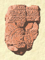
Babylonian clay tablet world map, 600 B.C. |
|
|
|
||
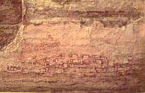 |
CATAL HOYUK MAP, Turkey, c. 6,200 BC
One of the earliest maps is the one discovered during an excavation in 1963 by James Mellaart in Ankara, Turkey at the archeological site at Catal Hoyuk (pronuonced Chatal Hoeyuek) in central Anatolia. This is a wall painting that is approximately nine feet long. It is believed that the map depicts the town plan of Catal Hoyuk itself. In the foreground is a town arising in graded terraces. Behind the town is an erupting volcano. This is possibly Hasan Dag. For more information please click on the map. |
|
|
|
||
.jpg) |
WORLD ACCORDING TO HERODOTUS, c. 450 BC
This a reconstructions of the oikumene (inhabited world) of the reknown historian Herodotus (active 440-425 B.C.) Herodotus was not only a great writer, but he was also an adventurous traveler. His researches took him from his home in Halicarnassus (present day Bodrum) in Anatolia through most of the known world of his time. His geographical descriptions are based on observations that he made on his journeys, combined with what he learned from the people he met. For more information please click on the map. |
|
|
|
||
.jpg) |
WORLD ACCORDING TO ERATOSTHENES, c. 194 BC
A 19th century reconstruction of the world view of Eratosthenes of Cyrene (275--194 B.C.). The partitions on the map are the forerunners of parallels and meridians. Geographic information gathered by Alexander the Great and his successors was the primary source used by Eratosthenes. For more information please click on the map. |
|
|
|
||
.jpg) |
STRABO'S WORLD, c. 18 AD
A 19th century reconstruction of the world view of the Greek philosopher Strabo who wrote the famous Geographia compiled from travelers' reports and the "writings" of ancients. The now lost map by Strabo represented the sum total of cartographic knowledge before the Christian Era. Strabo was born in Amasia [present Amasya] in Anatolia in 64 B.C. He was educated at Nysa near Tralles in Caria and in 44 B.C. went to Rome, where he continued his studies. From about 25 to 20 B.C. he was based in Alexandria. His Geographia was written between 9 and 5 B.C. and parts revised in AD 18-19. It is through his writings that most of our knowledge of Eratosthenes' mapping has come down. For more information please click on the map. |
|
|
|
||
.jpg) |
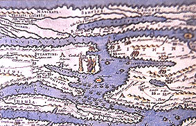
ORBIS TERRARUM, Marcus Vipsanius Agrippa, c. 20 AD
This is the reconstruction of Agrippa's Orbis Terrarum based upon data in the medieval world maps that were, in turn, derived from Romanoriginals. The profound difference between the Roman and the Greek mind is illustrated with peculiar clarity in their maps. The Romans were indifferent to mathematical geography, with its system of latitudes and longitudes, its astronomical measurements, and its problem of projections. What they wanted was a practical map to be used for military and administrative purposes. Disregarding the elaborate projections of the Greeks, they reverted to the old disk map of the Ionian geographers as being better adapted to their purposes. Within this round frame the Roman cartographers placed the Orbis Terrarum, the circuit of the world. For more information please click on the map. |
|
|
|
||
.jpg) |
PTOLEMAIC MAP Tabula Nova Asie Minoris , Claudius Ptolemy, c. 200 AD
This a reconstruction of Ptolemaic map by Johan Scotus in 1525. The famous scholar Claudius Ptolemy who lived in Alexandria, Egypt between the years 87 - 165 AD is one of the most important contributors to the development of cartography. Ptolemy's is the first known projection of the sphere onto a plane. His work titled GEOGRPHIA remained to be the principal work on the subject until Renaissance and inspiration for later cartographers. Unfortunately none of his maps have survived to our time. However, there are a quite a number of later reconstructions. As cartographic knowledge they represent Ptolemy's time. I put together several examples in a special section where you can go by clicking on the map. For more information please click on the map. |
|
|
|
||
 |
TABULA PEUTINGERIANA, Castorius, c. 1st Century AD
A detail from the reproduction of the early road map of the imperial highways of the Roman world showing Anatolia and its environs. Only a copy of the orignal map made in 1265 by a monk at Colmar has survived. The entire map was originally a long, narrow parchment roll 6.75 meters long but only 34 centimeters wide. The map does not conform to the rules of any projection, nor is it possible to apply a constant scale to determine distances from place to place; for these measurements we have to refer to the figures written in by the author. For more information please click on the map. |
|
|
|
||

 Recommended Recommendedreading |
 Recommended Recommendedreading |
||