 |
  |
18th - 19th Century Maps (continued) In the 19th Century we see serious changes in the map of the Ottoman Empire with the growing idea of Ethnic Nationalism in Eastern Europe and expansion of Colonial Powers in North Africa. Within the vast territories administered by the Ottomans during their reign of 700 years, there are over 20 independent nations today in North Africa, Balkans, Middle East, Caucasus and Arabian Peninsula. |
|
|
|
||
.jpg) |
THE TURKISH EMPIRE IN EUROPE, ASIA and AFRICA, London, c. 1730
MOLL, Herman. Moll's large-format two piece map of the Turkish Empire in Europe, Asia and Africa, divided into all its Governments, together with the Other Territories that are Tributary to it, also covering the whole Mediterranean. The insets are of Constantinople, Smyrna (present day Izmir) and Jerusalem, and three views of the Holy Sepulcher. |
|
|
|
||
 |
A New & Accurate Map of Turky in Europe, with the adjacent Countries... London, c. 1752
BOWEN, Emanuel Map of Ottoman territories in Europe Published in the "Complete Atlas", with an illustrated title cartouche depicting Ottoman characters with Istanbul in the background.
Map of Turky in Asia, London c. 1752 BOWEN, Emanuel Regional map of Ottoman territories in Anatolia and Middle East with a pictorial title cartouche published in the same atlas. |
|
|
|
||
.jpg) |
ESTATS DU GRAND-SEIGNEUR EN ASIE, Empire de Perse, Pays des Usbecs, Arabie et Egypte. Paris, c.1753
VAUGONDY, D. Robert De A regional map of Middle East showing the Asian territories of Ottoman Empire and neighboring countries.
|
|
|
|
||
 |
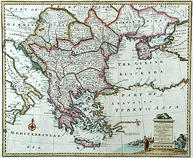
EUROPEAN DOMINIONS of the OTTOMANS, c.1720
FADEN, W. The Ottoman Empire, covering the Balkans and Anatolia with an attractive title cartouche.
|
|
|
|
||
.gif) |
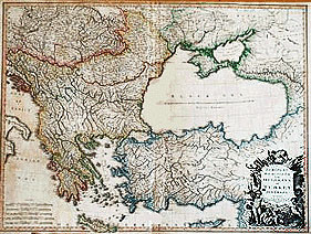
EUROPEAN TURKEY, Üsküdar c.1803
MAHMUD RAIF This is an Ottoman translation of William Faden's Atlas published by Mahmud Raif Efendi under the title of Jedid Atlas Tercumesi (Translation of New Atlas). All inscriptions are in Turkish written in Arabic scripture used by the Ottomans. The map shows Ottoman territories in Europe and Anatolia.The cartouche has been modified by omitting the Christian elements. Map is in outline colour. Size 530 x 860 mm.
|
|
|
|
||
.jpg) |
TURQUIE d'ASIE, Arabie, Perse ...., Paris, c.1806
VAUGONDY, G. Robert de. A regional map of Middle East showing the Asian territories of Ottoman Empire and neighboring countries.
|
|
|
|
||
.jpg) |
TURKEY IN ASIA, Philadelphia, c. 1824
FINLEY, A. Detailed map showing Ottoman territories in Asia from Finley's A General Atlas. |
|
|
|
||
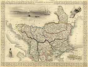 |
TURKEY IN EUROPE, New York, c. 1851
TALLIS, John An attractive map of Ottoman territories in Europe after the independence of Greece. Inset shows Candia (Crete) whic is still under Ottoman rule. This map is in outline colour with a view of Bosporus in Constantinople and depictions of local people. The map has a decorative border. Size 270 x 330 mm. The illustrations are by H. Warren and engraved by J. Rodgers. Map drawn and engraved by J. Rapkin. |
|
|
|
||
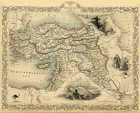 |
TURKEY IN ASIA, New York, c. 1851
TALLIS, John This is also from the same atlas as the map above. It is also in outline colour. Drawings include a view of Jerusalem, local characters and an ostrich. The map is sorrounded by an attractive border. Size 290 x 380 mm. Illustrations are by H. Warren and engraved by J.B. Allen. Map drawn and engraved by J. Rapkin. |
|
|
|
||
.jpg) |
TURKEY in Europe, New York, c. 1860
JOHNSON, A.J. Detailed regional map of Ottoman territories in Europe from Johnson's New Illustrated Family Atlas. These steel plate maps are quite decorative with their wash and bold outline coloring and typical frames. The inset map is the island of Crete. Size 310x420 mm. |
|
|
|
||
.jpg) |
TURKEY in Asia, Persia, Arabia, New York, c. 1860
JOHNSON, A.J. Detailed regional map of Middle Eastern countries showing Ottoman territories in Asia from Johnson's New Illustrated Family Atlas. These steel plate maps are quite decorative with their wash and bold outline coloring and typical frames. The views are of Muscat, Black Sea town of Trebisond (Trabzon) and Port of Smyrna (Izmir). Size 310x420 mm. |
|
|
|
||
 Recommended Recommendedreading |
 Recommended Recommendedreading |
||
|
|||